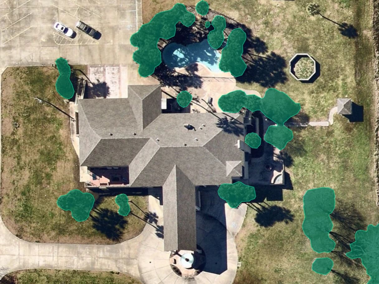
Vegetation and surrounding grounds
Review the relationship between trees, buildings, and outdoor areas to prepare grounds-maintenance and risk-review questions.

Aerial Imaging Report (AIR)
An Aerial Imaging Report (AIR) combines available aerial property imagery, historical views, and AI-based indicators to help you review roofs, sites, and surrounding conditions—for one property or an entire portfolio.
Review before a visit, compare changes over time, or prioritize follow-up after a major event.
What AIR is
AIR brings available aerial imagery and property intelligence into a report shaped around the questions your team needs to answer. High-resolution aircraft imagery can show roof and site detail that a ground-level visit—or a general satellite map—may not provide.
ForeFront360 checks the available views, dates, and permitted use, then organizes selected information for insurance, operations, projects, or property review. The report’s contents are confirmed before you order.
Why it matters
See roofs, surrounding grounds, building relationships, and access context so the next site visit starts with better questions.
Review available capture dates side by side to identify visible changes to roofs, vegetation, surfaces, and site features.
Use available post-event views to identify properties that may need closer follow-up and help coordinate inspection priorities.
Apply a consistent review approach across individual addresses, multi-building campuses, portfolios, or regional property groups.
Bring exterior context into underwriting, risk review, due diligence, maintenance, and capital-planning discussions.
Pair aerial context with measured floor plans, virtual tours, and on-site documentation to reduce gaps between interior and exterior information.
The information behind the view
AI-based attributes in the available library. Selected layers depend on scope and coverage.
Historical imagery may be available in covered areas. Location history varies.
Potential post-event publication window after capture. Flying conditions and availability apply.
Review the latest available capture—not a live feed. Overhead views show roofs and sites; angled views may add exterior context where available. Capture dates, resolution, and coverage are confirmed for each location.
Historical aerial imagery may be available back to 2014 in covered areas. The earliest image and number of available captures vary by location; we check the dates for your property before defining the report.
AIR can draw on a library of more than 130 AI-based property and site attributes or layers. A layer highlights a category of potential features, such as vegetation, roof characteristics, surfaces, or ponding indicators. Available layers depend on location, capture, processing, and the agreed scope—not every layer is included in every report.
After major events, post-event imagery may be published within 24–48 hours of capture, once conditions allow aircraft to fly. This is not a guaranteed window from the event itself. Weather, region, access, coverage, and source availability affect timing.
Start with one building or organize selected addresses into a repeatable review. Campuses and regional groups can use consistent questions and capture-date references to prioritize follow-up.
Optional drone imaging can be discussed when available imagery does not answer the project question. Site access, operating conditions, permissions, and deliverables require a separate scope.
Before and after an event
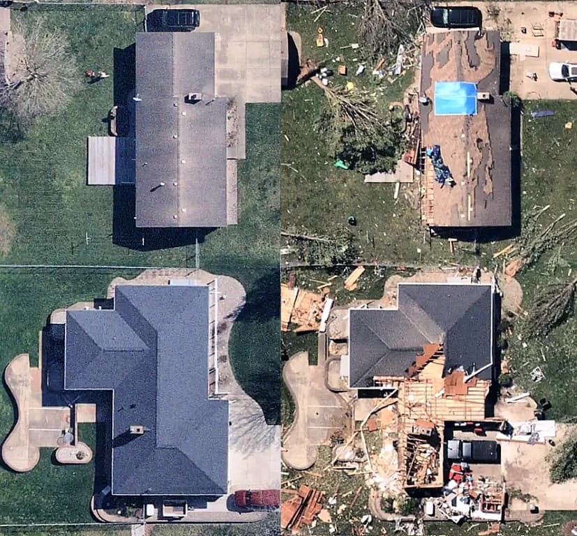
Compare captured roof and site conditions across dates to see visible changes and identify where closer review may be useful. Post-event imagery can help teams prioritize inspections across affected properties.
After major events, post-event imagery may be published within 24–48 hours of capture, once conditions allow aircraft to fly. This is not a guaranteed window from the event itself. Weather, region, access, coverage, and source availability affect timing.
Comparison imagery adds context; it does not by itself establish the cause, date, or extent of damage. Example capture dates and event details have not been supplied.
AI layers, explained
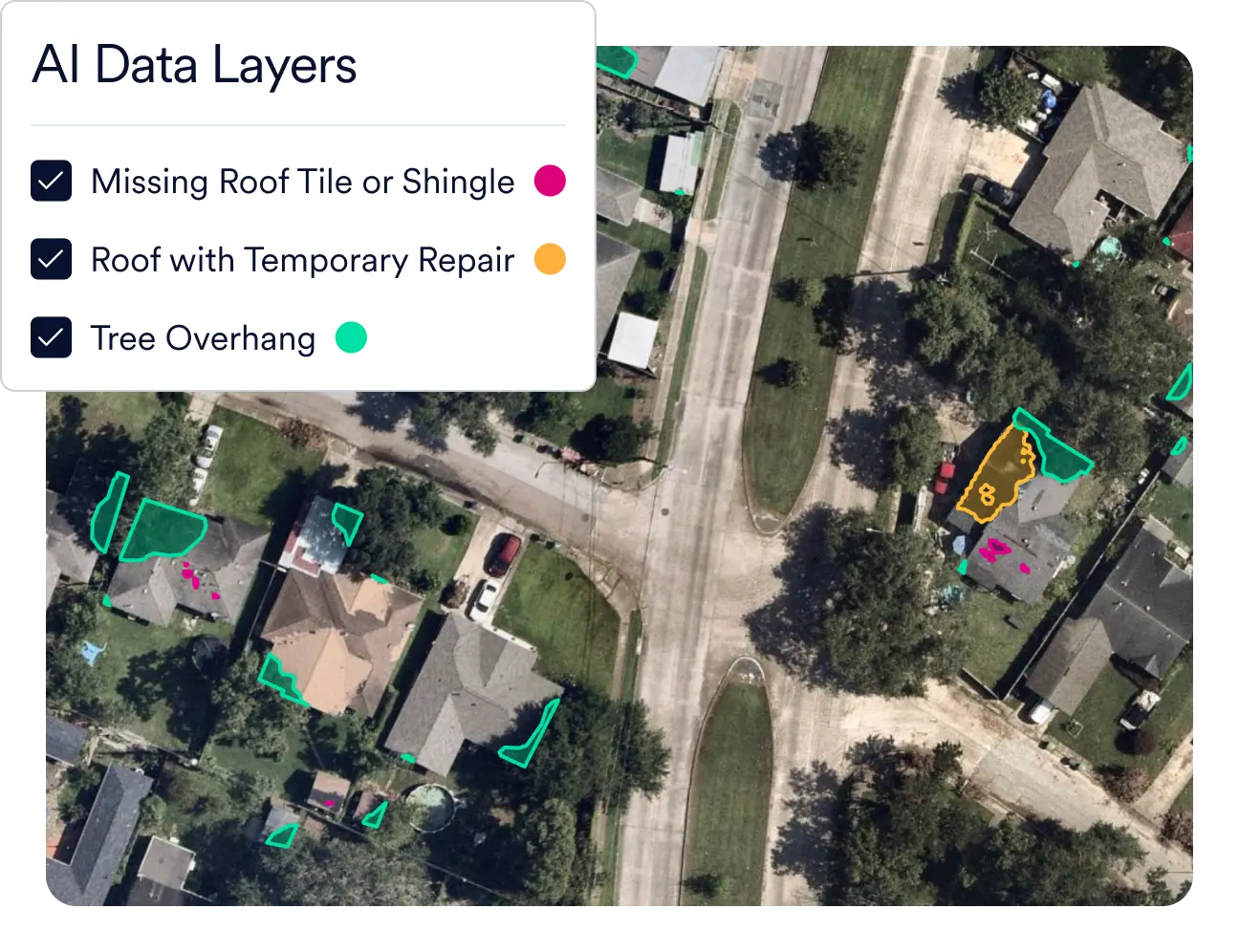
A colored overlay marks a category of potential features in the image. It helps focus attention; a person still needs to interpret the result and decide what requires inspection.
Review the relationship between trees, buildings, and outdoor areas to prepare grounds-maintenance and risk-review questions.
Available layers may flag potential temporary repairs, missing shingles, or tree overhang for closer review. Ponding-related indicators may also be available for selected captures.
AIR can draw on a library of more than 130 AI-based property and site attributes or layers. A layer highlights a category of potential features, such as vegetation, roof characteristics, surfaces, or ponding indicators. Available layers depend on location, capture, processing, and the agreed scope—not every layer is included in every report.
Who uses AIR
Add roof and site context to underwriting and risk review; use available post-event views to plan follow-up.
Explore your workflow →Review commercial or residential properties, compare visible changes, and prioritize due diligence or capital work.
Explore your workflow →Prepare maintenance discussions around roofs, vegetation, paved areas, and relationships between buildings.
Explore your workflow →Review multiple buildings and grounds with a shared exterior reference for facilities and project planning.
Explore your workflow →Add available site and post-event context to public-facility review and inspection priorities.
Explore your workflow →Support stewardship and maintenance conversations with a broader view of facilities and grounds.
Explore your workflow →Review surroundings and available historical changes alongside existing-condition documentation.
Explore your workflow →A connected property record
Roofs, grounds, surroundings, historical changes, and available post-event context.
Captured rooms, dimensions, visible finishes, and scoped equipment information.
Complementary records for insurance readiness, facilities, repairs, and project decisions.
Capture dates may differ. AIR and specialist deliverables are separately scoped; adding aerial information does not turn a property record into an inspection or certification.
From address to insight
Share addresses, priorities, intended users, and whether the goal is routine review, historical comparison, or post-event triage.
We confirm coverage, imagery dates, available layers, licensed use, and what can be included in the report.
Review the agreed imagery and observations, identify information gaps, and plan appropriate follow-up or complementary documentation.
Historical aerial imagery may be available back to 2014 in covered areas. The earliest image and number of available captures vary by location; we check the dates for your property before defining the report.
Before you order
An Aerial Imaging Report (AIR) combines available aerial property imagery, historical views, and AI-based indicators to help you review roofs, sites, and surrounding conditions—for one property or an entire portfolio. ForeFront360 defines the questions, checks available sources, and organizes the agreed imagery and observations for your intended use. It is more than a single overhead picture.
AIR can support commercial and residential properties, multiple buildings, campuses, portfolios, and regional property groups wherever appropriate imagery is available. We check each location and intended use.
The latest available image depends on location and capture schedules. It is not real-time imagery. Your review should use the actual capture date; publication and AI-processing dates may differ.
After major events, post-event imagery may be published within 24–48 hours of capture, once conditions allow aircraft to fly. This is not a guaranteed window from the event itself. Weather, region, access, coverage, and source availability affect timing.
Historical aerial imagery may be available back to 2014 in covered areas. The earliest image and number of available captures vary by location; we check the dates for your property before defining the report.
AIR can draw on a library of more than 130 AI-based property and site attributes or layers. A layer highlights a category of potential features, such as vegetation, roof characteristics, surfaces, or ponding indicators. Available layers depend on location, capture, processing, and the agreed scope—not every layer is included in every report.
No. AI detections are indicators for review, not guaranteed findings. They may miss or misclassify features. Image quality, shadows, capture date, and processing affect the result; relevant conditions need appropriate verification.
Available imagery can support internal property review, post-event triage, and planning where closer inspection is needed. AIR does not establish coverage, causation, or a settlement amount. Licensed imagery has use restrictions; sharing in a claim file or with outside parties must be confirmed before use, and legal use is not included.
Yes. Roof and site context can help teams identify questions about vegetation, surfaces, potential ponding, and access before arranging closer review. Pair it with equipment records and interior documentation for a more useful facilities reference.
Yes. Share the addresses, regions, priorities, and decisions you need to make. We can discuss a consistent report scope across locations while accounting for different capture dates and coverage.
AIR adds roof, exterior, and surrounding-site context to Safeguard Property Profile, measured plans, virtual tours, facilities documentation, and construction records. Each captures different information. AIR is separately scoped, and the records may have different capture dates.
No. Aerial imagery cannot reveal every condition, concealed damage, or interior details. It supports preparation and prioritization; it does not replace inspection, engineering, or other professional evaluations.
Your proposal defines the report, selected imagery, dates, observations, and permitted use. It does not automatically include raw data exports, every AI layer, unrestricted redistribution, or a software subscription. Confirm intended users and sharing before ordering.
Bring the property into view
Tell us the location and the question. We’ll check available imagery and define an Aerial Imaging Report for your property, campus, or portfolio.
Discuss your Aerial Imaging Report